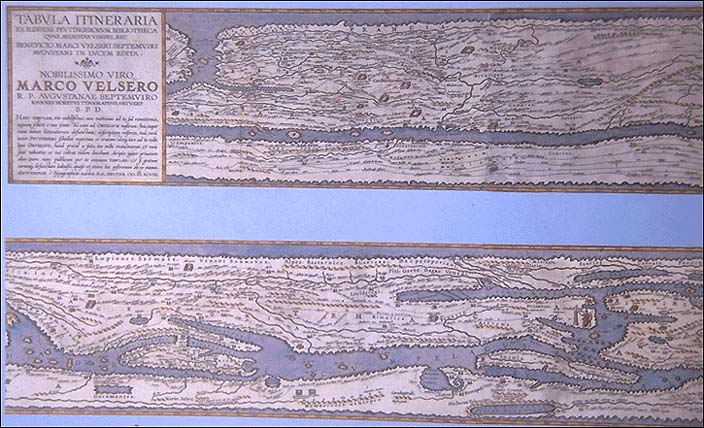

According to most authorities, about A.D. 250 the original tables were, themselves, copied from a larger original map of the first century A.D. (some scholars have identified that the author may have used M.V. Agrippa's world map as his source (Slide#118). About A.D. 350 the presentation of the coastal regions was improved and some islands were added. At the turn of the 5th-6th centuries the world ocean was added and improvements were made to the seas; at about the same time, the influence of this map appears in a work by an anonymous cosmographer of Ravenna, who made use of some new material recently added to his source. Since the Ravenna cosmographer names a certain Castorius as the author of his source in connection with material also found in the Tabula Peutingeriana, it is to be inferred that this was the maker's name for the original. The overall form of the Colmar edition, which is the basic form of the Tabula as it has reached us today, must have been fixed at this period, about A.D. 500; although a few local corrections were made subsequently, for example, in the 8th and 9th centuries.
This Colmar copy was found by Konrad Celtes (1459-1508), a German poet and scholar for the Emperor Maximilian I and later turned over to Konrad Peutinger (1465-1547) in 1508 in Augsburg and has since been known as the Tabula Peutingeriana or Peutinger Tables or Itineraries. After Peutinger's death, two of the twelve sections of the Colmar manuscript were engraved and published in 1591 with annotated text and place-names taken from the sections reproduced. A second edition by Abraham Ortelius was published in Antwerp in 1598 as part of his Theatri Orbis Terrarum Parergon which contained eight of the twelve sections of the Table. Numerous other engraved reproductions were made until 1753 when it was finally reproduced in its entirety.
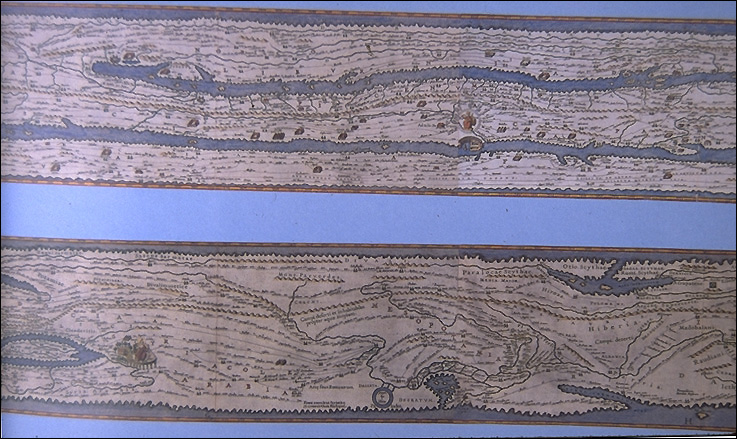
In its design, the Peutinger Table makes no pretense of showing the whole world or even its major parts in correct proportion. It is merely a graphic compendium of mileages or basically an itinerary route map with the roads delineated predominantly by straight lines, often with curious jogs. The routes are drawn in red, while the sea is indicated by greenish-blue. The map does not conform to the rules of any projection, nor is it possible to apply a constant scale to determine distances from place to place; for these measurements we have to refer to the figures written in by the author. Also the Table was not apparently designed for military use, but instead gives prominence to trading centers, mineral springs, places of pilgrimage, mountain chains (in profile) and in three great cities (Rome, Constantinople and Antioch) set three rulers, believed to represent the sons of Constantine enthroned as symbols of a tripartite empire. The use of vignettes and/or medallions is also found depicting the city of Alexandria, while smaller towns are illustrated by little houses; three forest districts, two in Germany and one in Syria, are represented by sketches of trees.
LOCATION: Österreichische National Bibliothek, Vienna
REFERENCES:
Bagrow, L., The History of Cartography, pp. 37-38.
Beazley, C., The Dawn of Modern Geography, vol. I; pp. 381-383.
*Bricker, C., Landmarks in Mapmaking, pp. 21-22.
*Brown, L., The Story of Maps, pp. 54; 92-93.
Brown, L.A., The World Encompassed, No. 5.
*Dilke, O.A.W., Greek and Roman Maps, pp. 112-120, 128, 152-3, 158-9,
169-70, 193-5.
*Harley, J.B., The History of Cartography, Volume One, pp. 238-242.,
Plate 5
*Nebenzahl, K., Maps of the Holy Lands, pp. 20-23, Plate 4 (color)
*Nordenskiöld, A.E., Facsimile Atlas, p.35.
*Jansoon, Tabula Itineraria ex illustri Peutingerorum Bibliotheca quae
Mugistae Vindelicorum beneficio Marci Velseri SeptemVeri Augustani in lucemedita,1741.
*illustrated
A portion of the Puetinger Map: Western Asia Minor and Egypt.
The elongated deformation of the map is shown by the ribbon-like representation
of (top-to-bottom) the Gulf of Azov and the Black, Aegean, Mediterranean,
and Red Seas. Constantinople is named as such and not as"Byzantium", which
confirms the pre-5th century date of the archetype. Its personification
is in the form of a female warrior, enthroned with a shield and spear.
Close by are a column and a statue, presumably of Constantine the Great.
(original size: 33 X 56. cm)